
 July 16, 2026
As Californians settle into our summer of 2026, we’re hearing more about a possible El Niño event this coming winter. And not just any El Niño event—possibly one for the ages.
The National Oceanic and Atmospheric Administration’s Climate Prediction Center predicts a greater than 60% chance of a “very strong” El Niño through January that would rank among the most powerful on record going back to 1950. It also has the potential to be the costliest on record, possibly surpassing $5.5 trillion in global financial losses after widespread flooding in 1997-98 due to El Niño conditions.
Climate scientist Dr. Daniel Swain focuses on the dynamics and impacts of extreme events—including droughts, floods, storms, and wildfires—on a warming planet. He shares research (and sometimes warnings) on his popular blog Weather West, like this about the increasing likelihood of a significant El Niño event this winter.

“Multi-model ensemble predictions have become even more aggressive and are now explicitly predicting an El Niño of very strong, and quite possibly record-breaking, magnitude by autumn or early winter,” Swain published on June 11. “In fact, the just-released multi-model ‘superensemble’ predictions for June are nothing short of remarkable, with the median forecast from every single international model ensemble depicting at least a ‘strong’ event, and the majority indicating a top-tier, very strong-to-historic event.”
Swain holds joint appointments as a climate scientist within the California Institute for Water Resources at the University of California Agriculture and Natural Resources (UCANR) and as a research partner at the National Science Foundation National Center for Atmospheric Research.
Climate scientist Daniel Swain sat down with River Partners to explain what this year’s El Niño is looking like, how it compares with past events, and what impacts it might have on communities across California. Next month, Swain will be back to explore how restoring rivers reduces flood risk, builds climate resiliency, and how California policymakers can help protect the state’s most vulnerable communities.
- Part 1 – A “Very Significant El Niño Event” Could Collide with California
- Part 2 – Flood and Fire: What California Can Do in the Face of Dual Climate Threats
What should Californians understand about El Niño—and what it does and doesn’t mean for California?
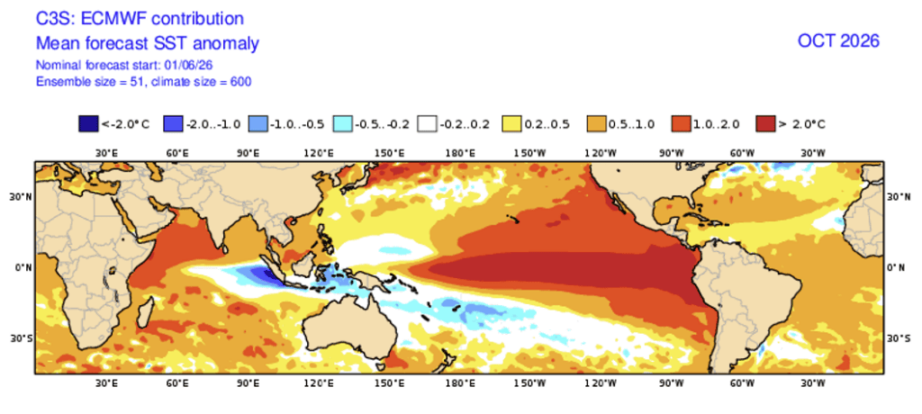
We’re likely headed for a very significant El Niño event this year—in fact, El Niño is already officially occurring. El Niño is not a thing that comes to California; it’s not a storm. El Niño is defined as anomalously warm water in the eastern tropical Pacific Ocean. And it has dramatic global implications, particularly when it is very strong.
At this point, it really does look like this year will end up with an El Niño that is among the strongest ever observed, with a possibility it could become the strongest ever observed, which is saying something since we’ve had some very big ones in the last 50 years. It’s globally significant because, of course, it’s occurring in the context of broader climate change and climate warming. And El Niño essentially exerts a mini global warming effect for a year or two, which acts on top of the not-so-mini, human-caused global warming effect that is not temporary.
We can see this pretty pronounced escalation of global temperature on top of an already record-high baseline. Ocean temperatures in the eastern tropical Pacific are warmer than they have ever been in all recorded history. Global average temperatures are edging up that high as well. This is something we expect to continue for the rest of the year into 2027 because of the combined effects of a very strong El Niño in all likelihood, plus the guaranteed effect of our climate-warmed baseline in 2026. That’s the global perspective: El Niño acts as this heat redistribution system, allowing years of stored energy in the tropical Pacific Ocean to be unearthed in the eastern tropical Pacific through evaporation, interestingly enough.
It is the process of evaporation that allows that energy to escape the tropical Pacific; it enters the global atmosphere, and causes all sorts of havoc and chaos for the six to 12 months thereafter, because you’ve released this huge pulse of multi-year, stored energy from the oceans into the atmosphere. It’s very concentrated where it’s released, and then it spreads and dissipates all over the world, and that’s how it creates all its indirect effects on global weather patterns and flood and drought risk, including in California.
In California, there are some short-term implications. The next few months, through the rest of summer and fall, will be warmer and more humid than average along the coast. There will be an elevated chance of those rare summer showers and thunderstorms in California, and we may see them at least once or twice later this summer. That includes Northern California and the coast, not just Southern California.
So that’s maybe more of a novelty, unless it’s a particularly intense event like the remnants of Tropical Storm Hillary, which moved over Southern California and brought record-breaking rainfall in August 2023. That was two or three inches of rain; it did cause some significant flash flooding in Southern California, but it also brought significant benefits in the form of a fire season that just ended in August. It was done. That could happen again, or we could have something more like 2020, where tropical remnants bring dry thunderstorms in unusually dry areas and cause wildfires.
How does a strong El Niño impact California’s winter weather, especially when it comes to rain, snowpack, and flood risk?
The real consequential effects of an El Niño event, I think, absent an errant tropical storm this summer or fall, is what might happen this coming winter in California. My new saying is that El Niño is both less important and more important than you think it is, depending on your perspective.
There are two different camps when it comes to El Niño in California, when it comes to rain, flood, or winter weather in general. Some folks say, “El Niño means wet and El Niño years are wetter years,” and other folks say, “We used to say that, and now we know it doesn’t matter at all. It doesn’t tell us anything. It can get wet or dry, it doesn’t matter.” The reality is neither of those two things is really true. El Niño indeed matters for California winter conditions, particularly for winter precipitation. And the strongest El Niño events are significantly more important.
If we had 100% likelihood of a weak to moderate event and low likelihood of a strong event this year, we wouldn’t be having this conversation. But for very strong events, like the one we’re likely to experience this year, the current single most likely outcome is a very strong El Niño event; we’re talking like 60%, 70%, 80% odds that that happens, which is very high looking forward from June. If that happens, it’s a completely different picture. And that significantly raises the odds of a wet winter overall, certainly in Southern California, but also, and this is notable, for Central and Northern California, specifically if it’s very strong.
There’s almost no signal if it’s weak to moderate, but if it’s very strong, that wet signal is a lot broader along the West Coast. And it does usually encompass Northern California and the Sierra Nevada watersheds as well. That’s about as strong a signal as we can get. There’s nothing else we know of currently in the climate system, season to season, within the same calendar year, that can tell us that much about what might happen this far in advance. The single predictor I would point to would be the presence or absence of a very strong El Niño event. And if we can say that’s probably going to happen, which we can this year, that’s a pretty strong statement.
Given all of that, the odds of a wetter-than-average winter are higher than the baseline statewide. It remains true that the largest and most consistent effect will be in the southern half of the state, but there is still significant tilt in the odds towards wet even in the north. In Southern California, the odds of a very wet winter increase quite a bit because very strong events have frequently produced [rainfall totals] 50-100% above average. So there’s likely going to be a statewide signal. It still doesn’t guarantee a wet winter, but it pushes us very hard into the direction of wetter-than-average.
Some other context here is that California is not entering this event from a severe multi-year drought perspective. We did have a terrible snow drought this past year, but interestingly, it was a snow drought. There was normal-ish precipitation, but it was record warm, and the snowpack was terrible. The reservoirs are in good shape; even soil moisture and groundwater aquifers are better now than they were during the 2010s drought.
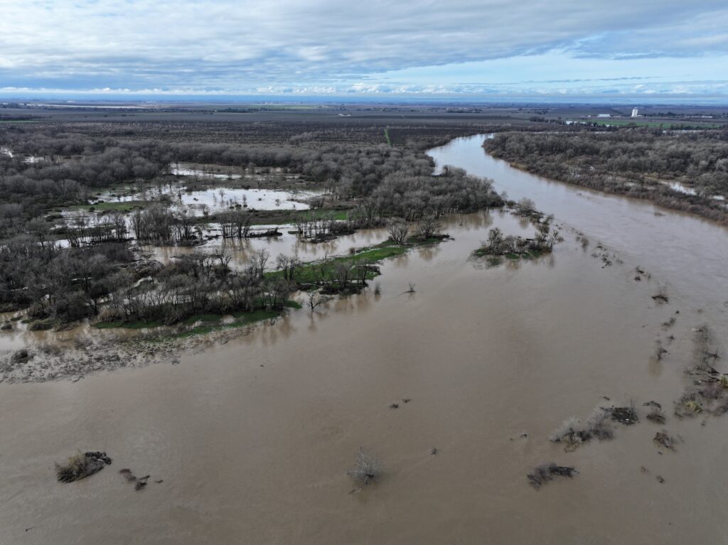
That also matters for the potential flood risk. It doesn’t necessarily increase the risk in itself, but it does remove some of the lowest-hanging fruit for where to put excess water if it arrives. It does mean that we’re not going to have critically low reservoir levels where you can just fill up two-thirds of the volume without any flood control concerns at all. We’ll probably have to release water as soon as the rains arrive because we’re already going to be pretty full. This is, again, good from a drought perspective, but it does shift flood management. It also means that the soil itself may be more responsive. We may not have to wait for two months of rain to soak in and saturate the soil column and produce base flow. That might happen with the first or the second storm of the season.
Some people point out that California’s largest 20th-century floods didn’t necessarily happen during major El Niño years. How useful is El Niño as a flood-risk signal?
Some California meteorologists point out that the largest historical floods in California (I’m being very deliberate with the use of historical; what this really means is 20th-century floods in California, which is not the same thing as all known floods) did not occur preferentially during significant El Niño events. My view is that has more to do with random chance than it does that strong El Niño events don’t actually increase flood risk. I think the reason for this is the really big flood events we’ve seen in California have been one region at a time for the most part in the 20th century.
There was a big North Coast flood one year, and there was a big Sacramento Basin flood another year, and then a San Joaquin Valley flood, and then the Central Coast and Southern California. They didn’t really overlap in time in the same way that some of the known megafloods of the geologic and oral histories suggested in centuries past, and also what climate models and paleoclimate proxies suggest. So we have pre-20th century human anecdata, we have paleoclimate records, we have climate model simulations, all of which suggest that we got lucky in the 20th century, and that the lack of association in the 20th century between big flood events and strong El Niño events is most likely to be a coincidence because in our own work, it really does look like a very strong El Niño event is the single greatest individual year risk factor in terms of a statewide major flood event.

How does flood risk intersect with atmospheric rivers?
When you have a big California flood, there’s usually an atmospheric river in the mix somehow—and, most often, more than one. But it’s usually not enough for there to just be an atmospheric river on its own. There needs to be a nearby low-pressure system that acts upon the atmospheric river. The atmospheric river essentially gives carte blanche to the low-pressure system, if you will, to go wild, in the sense that it gives it a lot of extra moisture to work with, it gives it extra “oomph” in the form of latent heating, it gives it a lot more space to work in. That’s what happened in pretty much all historical flood events, to one extent or another.
We have had some recent near-misses from a major flood perspective. In 2023, when we had this really wet winter overall, we got lucky in two distinct ways. That amount of water over a slightly more compressed period of time could have produced much worse flooding than we experienced. That same amount of water during a warmer winter could have produced much worse flooding. We could have had a terrible San Joaquin Basin snowmelt flood event, and we didn’t; it melted miraculously slowly. Amazingly enough, the evidence suggests that how cool it was during winter and spring 2023, and it was the coolest end to winter and beginning of spring we’ve had in many years, that in the current climate, that might be something like a 1-in-200-year event in terms of how cold it was. It was extraordinarily unlikely to have been as cold. In other words, we got lucky with a 99.5th-percentile cold winter in the present climate. We very likely will never have a winter that cold again for the rest of our lives.
The reason I raised that is not that it was an El Niño year, because it was not a significant El Niño year, but the reason I raised it is that that’s the model for how a big El Niño event would increase California flood risk. It’s because it results in a storm track that likes to fling storm after storm after storm toward the state over and over again, not all of which will be extremely strong. Some of them could be, but the bigger deal is it keeps the storm track pointed at California’s watersheds for weeks or months on end in a way that’s difficult to happen in other years. Not impossible. We had it in 2023. But this year’s strong El Niño event is also going to raise near-shore temperatures.
It brings a lot of water potentially, but it also means that that water is coming a couple or several degrees warmer than it would have been. If you add that to the warm climate baseline, that means we’re less likely to get lucky with a snowpack that takes the hit and absorbs the water and melts slowly. It also means that the antecedent conditions are more likely to be wet. If we have an early start to the rainy season, if it lasts a long time, you saturate the soils early, you get the rivers running early, which is good for every other reason except for flood risk. But for flood risk, it means you have a lot less margin to work with once these stronger storm sequences come, or perhaps a really big individual storm.
After providing background and context about the upcoming El Niño event, in Part 2 Dr. Swain will explore how Californians are being shaped by more extreme weather events and, more volatile weather regime; how state leadership has and should respond to extreme flooding, including increased funding for restored and reconnected floodplains statewide, and why a super El Niño this year could be a constructive rallying point around flood risk and solutions, both natural and built, to mitigate future impacts.