By Alastair Bland, December 4, 2018
| IN SUMMARY A growing emphasis on reconnecting California floodplains to rivers so they can absorb floodwaters is a U-turn from past reliance on levees to protect cities and towns. |
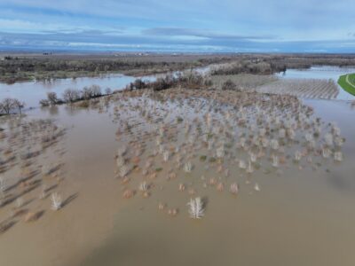
At the confluence of the San Joaquin and Tuolumne rivers, a winter of heavy rains could inundate about 1,200 acres of riverside woodland for the first time in 60 years. That’s by design: Here, a few miles west of Modesto, work crews removed or broke several miles of levee last spring and replanted the land with tens of thousands of native sapling trees and shrubs.
“We are very eager to see what happens when there is some overbank flooding here,” said Julie Rentner, executive vice president of River Partners, a habitat restoration group that is directing the project, known as the Dos Rios Ranch Preserve.
The work, much of it conducted by the California Conservation Corps, comes as the state overhauls its approach toward flood control, with a growing emphasis on reconnecting floodplains to rivers so they can absorb floodwaters. This shift in methodology marks a U-turn from past reliance on levees to protect cities and towns.
“It’s a paradigm change,” said Trout Unlimited biologist Rene Henery, who is among several California scientists helping drive the transition from “gray infrastructure” to “green infrastructure.”
A prime idea behind the surge of enthusiasm is simple: When a swollen river is allowed to flood in one location, it is less likely to inundate another. At the Dos Rios project, for example, the area newly opened to floodwaters could contain thousands of acre-feet of water that, in flood events, would otherwise flow straight downstream toward Stockton, a city of 310,000 people where a ruptured levee could be disastrous.
Climate change brings a sense of urgency to the matter.
“The modeling shows we are going to see a lot more extreme events, including flooding on our rivers,” said Ted Sommer, a biologist with the Department of Water Resources who has studied floodplain ecology for more than 20 years.
California’s Central Valley Flood Protection Plan, updated in 2017, warns that by late this century “flood magnitudes in some San Joaquin River watersheds are expected to increase by 60 to 80% relative to historical conditions.” This change—even greater than the 10 to 20 percent predicted for the Sacramento system—is expected mainly because warmer temperatures will cause more winter precipitation to fall as water, rather than snow, in the high Sierra Nevada, producing rapid flow surges downstream. The plan concludes that “wise land use and floodplain management…represent some of the most cost-effective means of reducing long-term flood risk.”
Inundated floodplains offer other benefits, too. When they soak up water, they help recharge depleted aquifers—currently a grave water supply issue in a drought-stricken state with a rapidly rising human population.
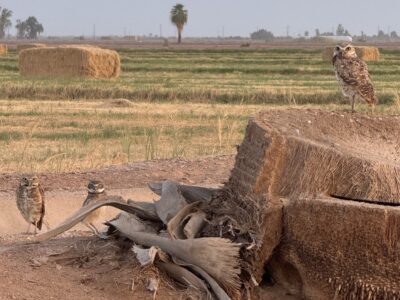
And they provide waterfowl and other wildlife with valuable habitat. Young Chinook salmon, for example, use inundated river valleys as feeding and refuge areas as they migrate toward the ocean.
Interest in using floodplains as absorptive shields against flooding in California started in the 1990s. But, said Jeffrey Mount, a senior fellow at the Public Policy Institute of California, “it takes decades to turn government policy into action, especially when you’re talking about knocking down levees.”
Now, that it’s starting to happen, scientists and nonprofit groups—including California Trout and The Nature Conservancy—have their eyes on roughly a million acres of historic floodplains that could potentially be reconnected to rivers with levee modifications. The 60,000-acre Yolo Bypass, a sprawl of fields and wetland a few miles west of Sacramento, is just one project on the to-do list. The Sutter Bypass, north of the capital, is another. River Partners alone hopes to restore 50,000 acres of floodplain in the next decade.
Funding is coming mostly from state agencies. To date, the California Department of Water Resources has provided $13 million of the total Dos Rios project cost of $42 million, according to Rentner. The U.S. Bureau of Reclamation, the San Francisco Public Utilities Commission and other agencies have also chipped in millions. Much of this money—about $14 million, Rentner said—has come from 2014’s Prop 1 water bond, which allocated $395 million in flood control funding.
Another $300 million from 2018’s Prop. 68 is designated for projects that simultaneously improve public safety and fish and wildlife enhancement—money that underwrite restoring floodplains.
While they have yet to encounter strong opposition, some farmers remain cautious about what floodplain projects could mean for their properties. Floodwaters were long considered anathema to farming, particularly for orchard-growers and others with permanent root stock who feared rot, fungus and disease from the inundation.
But recent persistent drought has prompted a rethinking, with some agriculture interests teaming with UC Davis to experiment with flooding on fallow farmland.Nonetheless the floodplain strategy remains a concern for others. And Justin Fredrickson, the California Farm Bureau Federation’s environmental policy analyst, also noted the risk that renewed annual flooding of land that has remained more or less high and dry for decades could allow jungle-like riparian woodlands to overgrow some parcels. Because of rules about clearing such vegetation, “it can be almost impossible to get that land back,” Fredrickson said.
Even among seasonal crop farmers, there are timing concerns.
Read the original article on CalMatters.