The San Joaquin Valley is unlike any other region in the state and, arguably, the country. Sprawling across about 17.5 million acres, this valley boasts some of the most fertile soil found anywhere and has been feeding the world for 150 years.
But recently these agricultural and dairy operations have changed—trees and fields that once fed tens of millions are aging out, climate challenges like more intense droughts and floods have turned some of these farms into disaster zones, and some farmers have had enough of all of that.
And while most people are interested in the fruit, vegetables, and dairy products this region produces, River Partners, which has a long history of restoring vast tracts of marginal farmland in the Valley to bring historic floodplains back, wants to know what lies beneath the surface—specifically, what the ancient underground aquifers look like. This will help us better understand how water moves from the surface to below the ground to refill depleted aquifers and increase water supplies critical to California’s environment, communities, and economy.
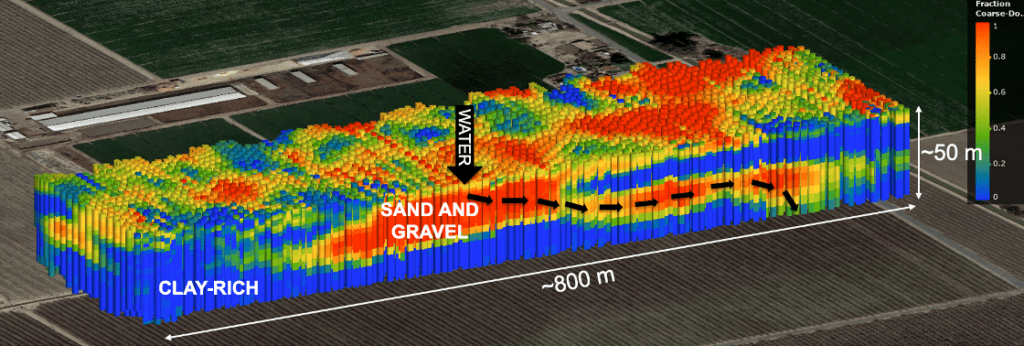
Last year, scientists from Stanford University used towed time-domain electromagnetic (tTEM) imaging, which acts like an MRI of the ground, to see where San Joaquin Valley rivers might flow more freely to encourage underground water recharge and where barriers to river-fed recharge exist. Scientists from Dr. Rosemary Knight’s research lab at Stanford spent several weeks gathering data from our Ott Farms, Grayson, Hidden Valley Ranch, Bear Creek Ranch, and Sweetwater property restoration and planning sites.
We are at a precarious moment in time. Over the past 150 years, unsustainable water use has led to depleted aquifers, land subsidence, streamflow depletion, and dry wells, threatening both human and environmental health. And rates of groundwater decline in California are some of the highest in the world, with four groundwater basins in the San Joaquin Valley ranking among the world’s most rapidly declining aquifers.
But River Partners is leading the way with our tenacity and innovation in our conservation efforts. The cumulative effect of scaling our proven restoration practices across California, expanding on-the-ground-science, taking bold risks, and forging diverse new alliances to deliver better, faster, and lasting revival of riverways have transformed over 20,000 acres in California and helped salmon, monarchs, migratory birds, and other imperiled wildlife.
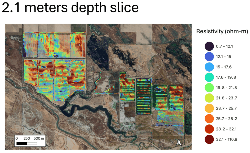
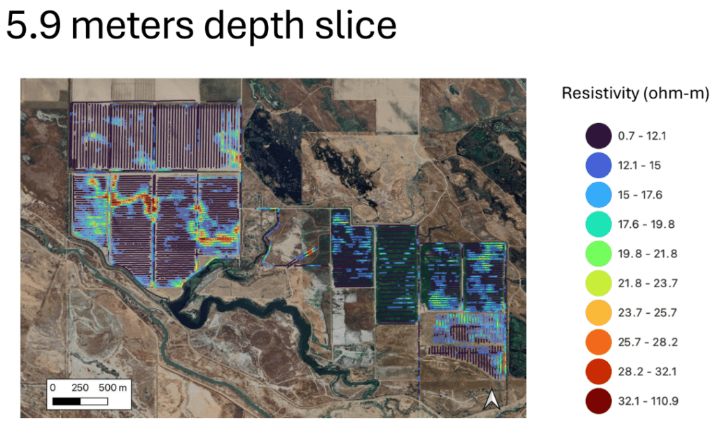
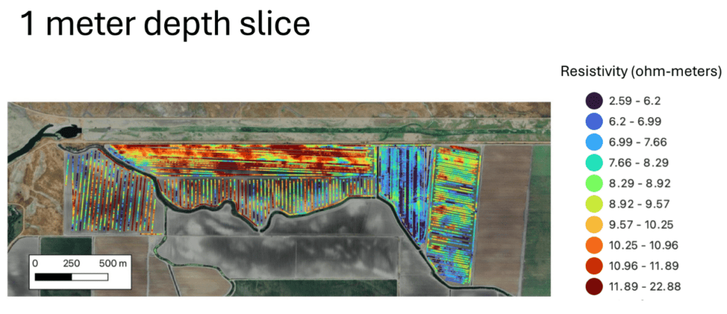
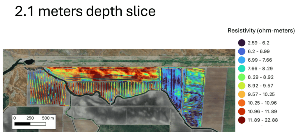
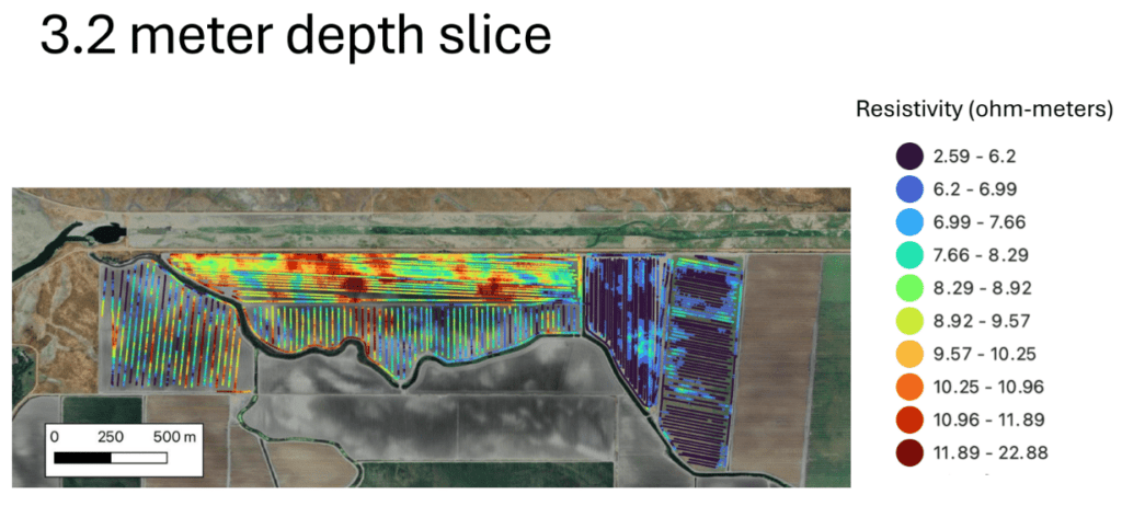
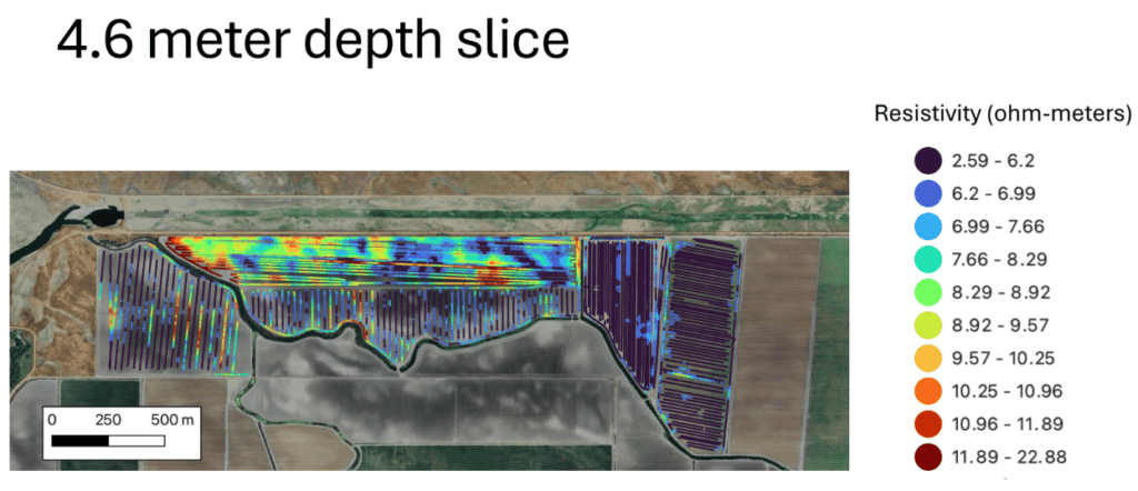
Earlier this spring, we received preliminary findings for Bear Creek Ranch and Sweetwater at five different depths: 1 meter deep, 2.1 meters, 3.2 meters, 4.6 meters, and 5.9 meters.
“We’re interested in trying to figure out the electrical resistivity of the subsurface, as that allows us to map out where there is clay or sand and gravel,” said Becca Prentice, a third-year Ph.D. candidate at Stanford and part of Dr. Knight’s team. “The data are giving us some insight as to what is actually beneath the ground.”
In many cases, the lower the resistivity, the higher the likelihood there are clays present which act as barriers to the flow of water—these are reflected in the imagery by cool colors, like blues and greens; higher resistivity is a good indicator of coarse-grained sand and gravel that can result in water flowing more freely in the subsurface—these are reflected by warm colors, like reds, oranges, and yellow.
While tTEM can collect data up to nearly 200 feet in depth, “at that depth, we won’t be able to see as much fine detail. And because we lose our resolution with depth, things would look a little bit more homogeneous,” said Prentice.
Bear Creek Ranch and Sweetwater sit just miles away in the heart of the San Joaquin Valley, and their restoration goals and objectives are generally the same, implementing multi-benefit restoration. So, what does it look like beneath the ground at these sites? And how will those conditions continue to inform our future restoration?
NOTE: All results are preliminary as Stanford scientists continue to refine resistivity models.
Bear Creek Ranch
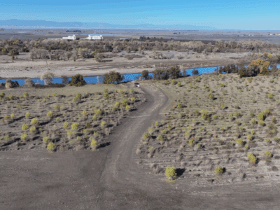
Bear Creek Ranch is located about 17 miles west of Merced in Merced County. River Partners’ efforts here will also focus on wildlife-friendly groundwater recharge areas and should benefit a wide array of riparian wildlife and migratory waterfowl.
The proposed restoration area spans approximately 1,200 acres of the 2,100-acre ranch, which sits in a major floodplain near the confluence of the San Joaquin River and Bear Creek. At one point in time, this site featured a diverse mosaic of seasonal and perennial wetlands and riparian habitats that flooded regularly and recharged local and regional aquifers.
Knowing that Bear Creek flows along the site’s southern border, it came as little surprise to see possible evidence of ancient riverbeds here, indicated by the red line meandering through the site.
“These are some areas that might be real good places for groundwater recharge,” Prentice said.
Evidence of ancient river channels that can still be detected nearly 20 feet underground underscores Bear Creek Ranch’s evolution over time, “especially in this part of the valley where the channels are very meandering and would have been myriad back in the day,” said River Partners Senior Restoration Science Ecologist Neil Wilson, who points to the Y-shaped pond in the middle of the imagery as additional change here.


“That’s an entire alternate primary channel to Bear Creek that’s been severed by the levee on both ends and trapped on this property,” he said. “That used to be yet another braided channel of Bear Creek.”
At 5.9 meters deep, the increased amount of low resistivity values (indicated by the dark gray) caught Prentice’s eye. This doesn’t necessarily indicate it’s all clay, because resistivity will also decrease if there’s higher salinity—which can be caused by fertilizers.
“Since these were agricultural fields that probably applied fertilizers, we think that when the fields flooded, the fertilizer flushed down to these deeper areas,” Prentice said. “This could be evidence of the flushing of those fertilizers causing the very low resistivities.”
But if this were clay, Wilson said he would not be shocked, as intermittent clay layers are one of the hallmarks of the San Joaquin Valley.
“That’s going to be the limiting factor moving forward for how deep this water can get and whether it will actually benefit any wells or groundwater-dependent ecosystems,” he said. “But for our additional purposes for habitat and wildlife, if the water stays shallow, that’s a great thing for riparian vegetation and grasslands, which can actually tap into water this deep.” Stanford scientists are currently working on a deeper analysis of the data at Bear Creek with the goal of having it finalized by the end of July.
Sweetwater
This 560-acre restoration project is adjacent to the sprawling 26,800-acre San Luis National Wildlife Refuge Complex in Merced County. With its focus on multi-benefit restoration, a restored Sweetwater will preserve and enhance habitat connectivity and help bridge the gap between the San Luis and Merced National Wildlife refuges, helping wildlife move safely across the Central Valley.
River Partners Restoration Science Ecologist Dr. Sarah Gaffney said that with a goal of multi-benefit restoration, if groundwater recharge happens at Sweetwater, that would be an even better outcome.
“We’re planning on creating a host of shallow ponds and swales around Sweetwater,” she said. “So these tTEM results will help us determine the best placement for those.”
Looking at 1 meter below the surface, the second field from the east of the property (on the right side) shows a lot of low resistivity, reflected with so much blue. This correlates to finer sediments and more barriers for water to flow through the ground surface. Mapping such low resistivity areas helps Gaffney and other ecologists plan plant communities that do well with water ponding on the surface for long periods of time. For example, vernal pools and alkali flats are ecosystems that only form in such areas.
“That could be due to some anthropogenic causes, since we’re only looking at 1 meter deep,” Prentice said. “Obviously, humans play a large role in what’s going on here, so different farming practices that occurred in this field, like using more fertilizers, could have caused these lower resistivities.”
Meanwhile, on either side of this plot are fields with higher resistivity, with pockets of coarser sediment for higher potential of water flow underground. Ponds and swales in these areas would help funnel rainwater or surface water into the ground, benefiting groundwater supplies and plants and animals that rely on groundwater.

As with Bear Creek Ranch, a faint line red line meandering from west to east through Sweetwater could be evidence of an ancient riverbed. We can even see how it once connected with Mariposa Slough, a historic side-channel of the San Joaquin River, which currently flows through this property.
In the heart of this site, however, are pockets of coarse sediment (in red). And as we look here at 2.1 meters deep, the resistivity remains high, showing increased potential for groundwater recharge.
“Such high resistivity at this spot that continues to occur as we go to deeper layers indicates that this area would probably be great for recharge and it’s connected down to the groundwater system,” Prentice said.
Beyond 2.1 meters deep, Sweetwater reveals mostly low-resistivity values with salinity issues, which could be due to fertilizer use or the sediments are naturally a little saltier, another hallmark of the bottomlands of the San Joaquin.
Gaffney said she’s not surprised that Sweetwater, an old agricultural site, has high salt accumulation in places. Taking all of this into account, she and other River Partners ecologists continue to formulate plans for planting and designing water features around Sweetwater for mammals and migratory birds—as well as the possibility of groundwater recharge.
“We would like to do these assessments on more sites where groundwater recharge is a multi-benefit,” she said. “As we continue restoring sites in the Central Valley, partnerships like those with Stanford will be valuable as we learn more about what it looks like beneath the soil surface.”
Stanford scientists will collect additional data on Sweetwater in the coming weeks to support additional analysis.
All tTEM imagery provided by Stanford University