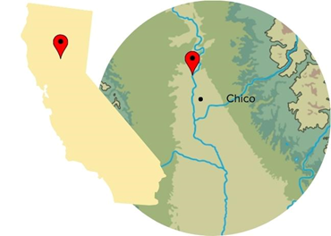
Sacramento Valley Project
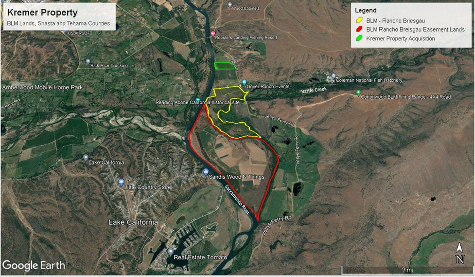
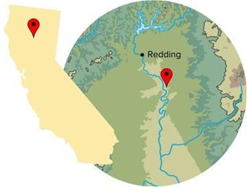
Kremer Property—Shasta County
Highlights
- Size: 45 acres—will unlock 800+ additional acres of land and water rights for conservation
- Annual VWBs: 152 acre-feet
- Total restoration cost: $1,380,000
This site involves restoring and permanently protecting 45 acres along the Sacramento River south of the city of Redding near the confluence with Battle Creek, one of only a few remaining streams in California, other than the mainstem Sacramento River, that sustains breeding populations of steelhead trout and all four runs of Chinook salmon.

Restoration activities include removal of irrigated pastureland and planting native riparian trees, shrubs, and an herbaceous understory of native grasses and forbs, and three years of irrigation, maintenance, and monitoring during the critical establishment period.
Restoration at the Kremer property is the first step in achieving landscape-scale land protection and habitat restoration at the confluence of two great salmon-bearing waterways, the Sacramento River, and Battle Creek where conservation ownership of water rights is critical to protecting upstream and downstream salmon habitat. Restoration of this parcel will set the stage for an additional 800 acres of conservation transactions along lower Battle Creek in a stretch of floodplain between this parcel in the north and the Rancho Briesgau unit in the south, which sits at the confluence of Battle Creek and is undergoing restoration right now. The Kremer property will create a northern bookend of permanently restored floodplain, creating an incentive for landowners between the Kremer parcel and Rancho Breisgau to sell flood-imperiled properties into conservation ownership.
River Partners long-term vision is to preserve a total of 845 acres and restore over 1,600 acres of land at this critical confluence. In restoring the Kremer property, we are initiating an intended domino effect of neighboring transactions with state and federal support that will keep significant amounts of water in the Battle Creek watershed.
Co-Benefits
- Wildlife habitat for a variety of imperiled aquatic, terrestrial, and avian species, including the yellow-billed cuckoo, Valley elderberry longhorn beetle, least Bell’s vireo, Swainson’s hawk, willow flycatcher, Peregrine falcon, and bald eagle
- Increased stream flows and floodplain connectivity to support migratory spring, fall, late fall, and winter-run Chinook salmon and other imperiled fish and aquatic species
- Increased flood safety for downstream communities
- Recreational use for public, including birding, hiking, and water access
- Supporting Tribal cultures through access to native vegetation for creating baskets, tools, traditional foods, and other culturally significant items
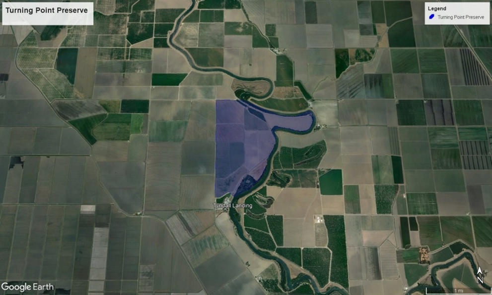
Turning Point Preserve, Phase 1 & 2 restoration—Yolo County
Highlights
- Size: 205 acres
- Annual VWBs: 152 acre-feet
- Total restoration cost: $9,257,500
The 1,000 acre Turning Point Preserve lies within a 30-mile stretch of the most constrained and habitat-poor section of the approximately 385-mile Sacramento River. Levees on both sides of the river from the small farming town of Colusa in the north to the city of Sacramento in the south disconnect the river from its historic floodplains.
Two riverside parcels will be reconnected to the floodplain in two main phases that will restore historic features of the meandering river for both ecological and community benefits. Restoration activities include removal of field crops and weedy vegetation, planting native riparian trees, shrubs, and an herbaceous understory of native grasses and forbs, and three years of irrigation, maintenance, and monitoring during the critical establishment period. The overall restoration complements noteworthy public and private conservation efforts—including California’s 30×30 initiative, the multi-stakeholder Sacramento River Salmon Recovery Program, and the recently updated Central Valley Flood Protection Plan—to restore thousands of acres of riverside habitat throughout the Sacramento River system over the next several decades.
Co-Benefits
- Wildlife habitat for a variety of imperiled aquatic, terrestrial, and avian species, including the Swainson’s hawk, migratory shorebirds, millions of waterfowl that migrate along the Pacific Flyway each year, and important pollinators such as bees and monarch butterflies.
- Increased stream flows and floodplain connectivity to support all four runs of endangered Central Valley Chinook salmon runs, Central Valley steelhead, Sacramento splittail, and other struggling fish
- Increased flood safety for downstream communities
- Recreational use for public, including birding, hiking, and water access
- Supporting Tribal cultures through access to native vegetation for creating baskets, tools, traditional foods, and other culturally significant items
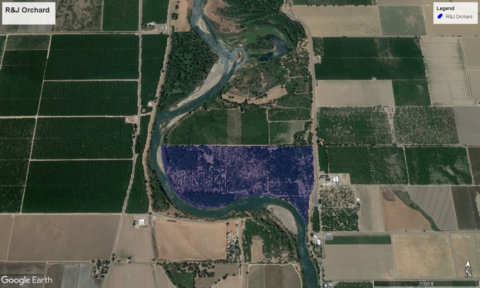
R&J Orchard—Colusa County
Highlights
- Size: 183 acres
- Annual VWBs: 850 acre-feet
- Total restoration cost: $8,763,000
The R&J property is currently farmed in walnuts. Because it was never laser-leveled, the orchard retains topography including natural depressions and drainages that will enhance and support restoration to support fish and other species habitat, as well as conservation and repurposing of freshwater resources. The landscape grading River Partners will do will enhance these natural features, followed by planting of a wide assortment of native trees and vegetation.
Grading will allow more floodwater to inundate the site and remain on the landscape for longer periods of time to provide a range of ecosystem and community benefits. This includes increasing natural floodplain inundation and associated groundwater recharge, potentially improving downstream flood protection, and boosting floodplain connectivity to increase available food supplies and rest stops for migrating salmon and other imperiled fish in the Sacramento River.
Co-Benefits
- Wildlife habitat for a variety of imperiled aquatic, terrestrial, and avian species
- Increased stream flows and floodplain connectivity to support endangered Chinook salmon, steelhead, and other struggling fish
- Increased flood safety for downstream communities
- Recreational use for public, including birding, hiking, and water access
- Supporting Tribal cultures through access to native vegetation for creating baskets, tools, traditional foods, and other culturally significant items
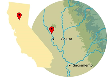
Colusa Bend—Colusa County
Highlights
- Size: 135 acres
- Annual VWBs: 526 acre-feet
- Total restoration cost: $7,567,000
Restoration of the Colusa Bend property will result in a range of ecosystem and community benefits. In addition to noteworthy water replenishment outcomes, restoration will reduce flood risk, provide increased recreational opportunities, connect an additional 450 acres of publicly owned land—a California State Park campground and a native habitat area owned by California Department of Fish and Wildlife (CDFW) – to restored habitat corridor, supporting the recovery of multiple imperiled species, including endangered Chinook salmon.
On this property, River Partners will create enhanced access and views of native habitat that will improve public greenspace and significantly reduce flood risk. The site, 65 acres of walnut orchards and ~85 acres of farmland used for winter wheat and row crops, floods with high frequency. Adjacent to the city of Colusa, the site is accessible from its downtown via a footbridge that we hope the town of Colusa will improve as the benefits of the restored open space area become evident to the community.
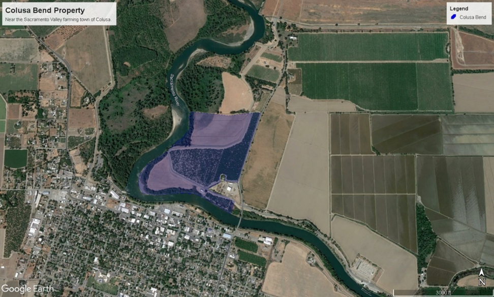
This site is immediately restorable. The densely vegetated native trees and shrubs across the site will help displace floodwaters and help them spread out and slow down, reducing surface water elevation by one tenth of a foot as it encounters the Colusa levee. Floodwaters will spread northward away from Colusa, up to one mile north, where they will empty into the Colusa Weir, reducing flood pressure on the town and its residents.
Co-Benefits
- Wildlife habitat for a variety of imperiled aquatic, terrestrial, and avian species
- Increased stream flows and floodplain connectivity to support endangered Chinook salmon, steelhead, and other struggling fish
- Increased flood safety for the town of Colusa
- Recreational use for public, including birding, hiking, and water access
- Supporting Tribal cultures through access to native vegetation for creating baskets, tools, traditional foods, and other culturally significant items
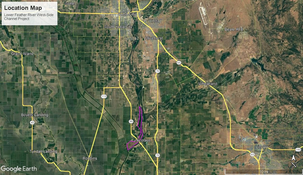
Feather River Floodplain and Side Channel Reconnection—Yuba County
Highlights
- Size: 53 acres
- Annual VWBs: 7,603 acre-feet
- Total restoration cost: $13,225,000
The site—located south of the twin cities of Yuba City and Marysville—will improve salmon and steelhead juvenile rearing habitat through the creation and restoration of up to five miles of side channels along the lower Feather River. Working in partnership with the US Bureau of Reclamation, River Partners will lead the planning, design, permitting, outreach, construction, maintenance, and post-restoration monitoring.
The Lower Feather River has been identified as a priority area for salmon and steelhead habitat restoration under the Central Valley Project Improvement Act Near-term Restoration Strategy (NTRS). The NTRS also identifies benefits to juveniles from increases in habitat connectivity with the Sacramento River.
By restoring and constructing new, frequently inundated side channels, this effort will create or improve hydraulic connectivity between the river channel and new side channel habitat. The efforts at this site will also enhance wildlife and bird habitat by creating more wetted areas, increased riparian vegetation, and enhanced connection to the mainstem of the lower Feather River. Specifically, the restoration will create side channel areas at two locations on adjacent properties: the 1) Garden Highway Mutual Water Company landowner group; and 2) Audubon California’s Bobelaine Sanctuary. Both landowners are supportive of the restoration (formal support letters available).
Co-Benefits
- Wildlife habitat for a variety of imperiled aquatic, terrestrial, and avian species
- Increased stream flows and floodplain connectivity to support endangered Chinook salmon, steelhead, and other struggling fish
- Recreational use for public, including birding, hiking, and water access
- Supporting Tribal cultures through access to native vegetation for creating baskets, tools, traditional foods, and other culturally significant items
Willow Bend, Phase 1 (Habitat Restoration) & Phase 2 (Side Channel)—Colusa County
Highlights
- Size: 203 acres
- Annual VWBs: 1,948 acre-feet
- Total restoration cost: $4,478,316
Situated along the active floodplain of the Sacramento River, Willow Bend encompasses over 200 acres of former flood-prone farmland. The site lies 1.5 miles along the east bank of the Sacramento River immediately upstream of Moulton Weir, the uppermost extent of the Sacramento Valley Flood Control System.
River Partners acquired the property in 2009, protected it in perpetuity with a conservation easement, and is actively currently implementing the establishment phase of restoration, which began in late 2022. Flood damage in the spring of 2023 required River Partners to grow-out additional plants that were planted in late 2023 and early 2024. Flood damage also damaged a water control structure that needs to be repaired to make it more resilient to future floods.
The property had been disconnected from the Sacramento River floodplain by a series of berms created by prior landowners. After purchasing the property, River Partners discovered that each time floodwaters overtopped the berms, thousands of tiny baby salmon were washed onto the property. While the juvenile salmon enjoyed bountiful phytoplankton that helped them grow and gain weight for their migration to the Pacific Ocean, there was no way for them to return to the river.
River Partners designed and installed a first-of-its-kind fish gate in partnership with the NOAA Restoration Center, Irrigation Training and Research Center at Cal Poly, San Luis Obispo, and UC Davis Center for Watershed Sciences that prevents juvenile salmon from being trapped on the restored floodplain. The non-electrical gate features concrete buoys that automatically adjusts according to water levels, opening and closing a bi-fold gate as floodwaters rise and recede, and allowing fish to swim and out without getting stranded.
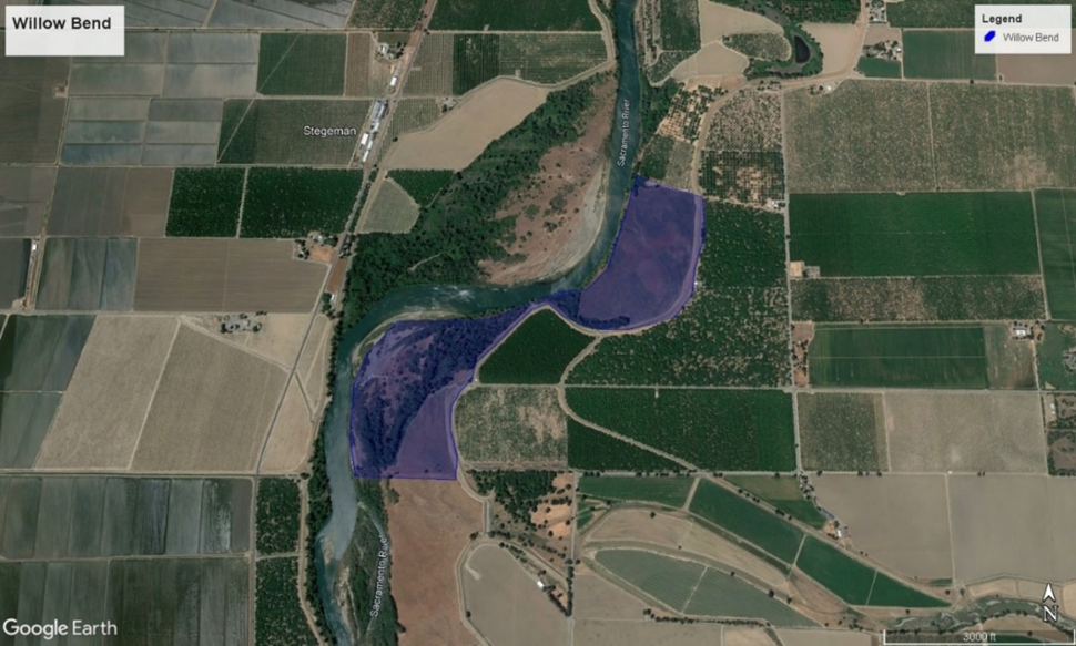
Phase 2—Side Channel Enhancement
The second phase of restoration kicked off in 2024 and involves reconnecting a remnant side channel on the property to enable river water and juvenile salmon to access 3,400 linear feet of side channel habitat and surrounding floodplain during annual flooding on the Sacramento River. The remnant side channel floods routinely under existing conditions, but juvenile salmon are stranded by berms that prevent the channel from draining after floods, resulting in the loss of juvenile fish that would otherwise be recruited to the population. The restoration will be designed to increase the frequency of inundation: it will remove the artificial blockages that cause fish stranding and mortality and slightly lower the channel to increase the frequency and duration of inundation. Analyses show that the site, under existing conditions, flooded 29 times in a 19-year period from 1998-2016. The design goal is to double the frequency and extend the duration.
Co-Benefits
- Wildlife habitat for a variety of imperiled aquatic, terrestrial, and avian species. The California Department of Fish and Wildlife identifies the site as an “irreplaceable and essential corridor” for wildlife
- Increased stream flows and floodplain connectivity to support endangered Chinook salmon, steelhead, and other struggling fish
- Recreational use for public, including birding, hiking, and water access
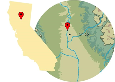
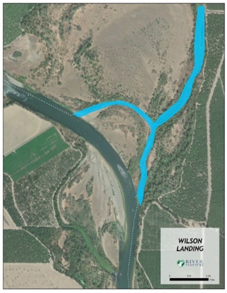
Wilson Landing—Butte/Glenn County
Highlights
- Size: 22 acres
- Annual VWBs: 7,128 acre-feet
- Total restoration cost: $2,737,412
Located a few miles upriver from the underserved and formerly flood-prone community of Hamilton City in Northern California, the Wilson Landing restoration involves modifying a remnant side channel to allow Sacramento River flows to inundate an area (see map) year-round that provides juvenile salmon access to high-quality rearing habitat.
The effort will reconnect 4,500 lineal feet of side channel habitat to perennial flows and add boulders and woody material to provide cover for juvenile salmon. In addition to this habitat, the restoration will also connect to the downstream end of the larger oxbow, effectively giving juvenile salmon access to another 4,700 lineal feet of prime off-channel rearing habitat.
The Wilson Landing site is located on the left bank of the Sacramento River just downstream of a pumping station owned by a local irrigation district. During the growing season (April-October), this pumping station diverts river water at an average of 2,000 cubic free per second, reducing the river’s flow by approximately 20% in this reach. This sudden flow reduction adversely affects the carrying capacity of the mainstem channel to support fish. Our hope is the restored side channel will reverse this effect.
Co-Benefits
- Wildlife habitat for a variety of imperiled aquatic, terrestrial, and avian species
- Increased stream flows and floodplain connectivity to support endangered Chinook salmon, steelhead, and other struggling fish
- Recreational use for public, including birding, hiking, and water access
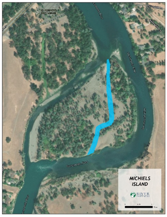
Michaels Island—Shasta County
Highlights
- Size: 4 acres
- Annual VWBs: 22,109 acre-feet
- Total restoration cost: $1,459,143
Michaels Island restoration will create over 3,700 linear feet of new perennially inundated side channels using significantly less river water to provide rearing habitat for the juvenile life stages of endangered salmon. Boulders and woody material, including logs, branches, and root wads, will be placed, and imbedded into the banks of these newly created channels to further enhance this habitat and provide protective cover for juvenile fish to rest and hide from predators. In addition to new rearing habitat, the cobble excavated from the island will be screened and placed in the mainstem river channel to create a large riffle, providing much-needed spawning habitat for adult salmon in the upper reaches of their current accessible habitat.
Co-Benefits
- Wildlife habitat for a variety of imperiled aquatic, terrestrial, and avian species
- Increased stream flows and floodplain connectivity to support endangered Chinook salmon, steelhead, and other struggling fish
- Recreational use for public, including birding, hiking, and water access
- Supporting Tribal cultures through access to native vegetation for creating baskets, tools, traditional foods, and other culturally significant items
Indian Fishery—Butte County
Highlights
- Size: 20 acres
- Annual VWBs: 950 acre-feet
- Total restoration cost: $4,952,116
The Indian Fishery site is located within the restored Bidwell-Sacramento River State Park. In this section of the waterway, the river’s banks start to become taller but seasonal flooding is more frequent.
The channel feeds into a perennially inundated oxbow where the mainstem of the Sacramento River once flowed up through the 1900s. Currently, the oxbow lake provides good habitat for river otters, pond turtles, egrets, and herons, and has a walking trail perched high above that is popular for viewing wildlife. Human modifications on the lower end, however, prohibit the oxbow from draining after a high-flow event, causing fish stranding to occur. Planned excavation of the channel below the oxbow will mitigate this hazard and reconnect the channel to the Sacramento River.
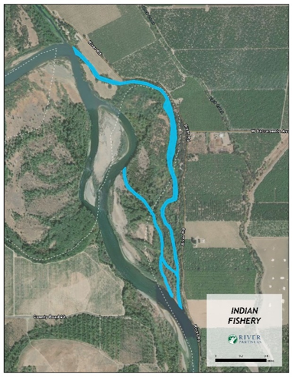
Restoration activities include modifying an existing high-flow floodplain channel to allow inundation at much more frequent flows—a minimum two-year frequency—and utilizing exponentially less river water to improve floodplain habitat for endangered salmon and a range of imperiled aquatic, terrestrial, and avian wildlife.
Ultimately, the effort will create over two miles of seasonally inundated juvenile rearing habitat at a minimum two-year frequency.
Co-Benefits
- Wildlife habitat for a variety of imperiled aquatic, terrestrial, and avian species
- Increased stream flows and floodplain connectivity to support endangered Chinook salmon, steelhead, and other struggling fish
- Recreational use for public, including birding, hiking, and water access
- Supporting Tribal cultures through access to native vegetation for creating baskets, tools, traditional foods, and other culturally significant items
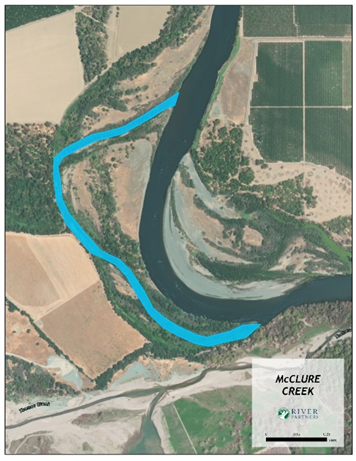
McClure Creek—Tehama County
Highlights
- Size: 20 acres
- Annual VWBs: 7,128 acre-feet
- Total restoration cost: $1,894,243
Seventeen miles downstream of the farming town of Red Bluff, the McClure Creek restoration involves modifying a remnant side channel on the west bank of the Sacramento River to provide year-round inundation to nearly two miles of much-needed rearing habitat for juvenile salmon including the endangered winter-run salmon and threatened spring-run. The engineered channel will require much less river water to create continual inundation, which will be attainable even in dry years, than the amount of river water needed to inundate the floodplain in its current state.
This site is a former mainstem channel that has experienced sediment deposition since it was cut off by the river, potentially during high-flow events in the 1980s or ’90s. Today, the inlet to this channel is located just upstream of an actively growing sandbar directly across the river. Sediment deposition along the McClure Creek inlet to the Sacramento River causes the channel to disconnect at lower river flows.
Co-Benefits
- Wildlife habitat for a variety of imperiled aquatic, terrestrial, and avian species.
- Increased stream flows and floodplain connectivity to support endangered Chinook salmon, steelhead, and other struggling fish

